No Warnings, Watches, or Advisories

NWS South Mississippi Valley Regional Radar WU South East Satellite
Radar/Satellite images courtesy of NOAA/NWS and Weather Underground.
spacer
METRIC | IMPERIAL
Updated: 03-May-2024 @ 5:45am   (0 sec ago)
Temperature Current Conditions Forecast / Storm Prediction
Currently Outside: No Change

66.8°F

Comfortable
High Today
72.2°F
12:00 AM
Low Today
65.9°F
3:43 AM
Yest High
86.5°F
2:01 PM
Yest Low
59.8°F
5:20 AM
Sta* High
86.2°F
2010
Sta* Low
40.4°F
2023
* This Station's Records Since 9/2009
Rec* High
90°F
1901
Rec* Low
37°F
2005
Avg* High
77°F
Avg* Low
55°F
* Records from NOAA
overcast -  light rain overcast - light rain

Calm Wind:  W
0.0

Gusting to:
0.0 mph
Current Rain Rain:
0.00 in
Chandler Burning Index: LOW Current CBI
Fire Danger:
-1.4 of 100
Overnight

Overnight: Showers And Thunderstorms Likely
Showers And T-Storms Likely
Friday

Friday: Showers And Thunderstorms then Showers And Thunderstorms Likely
Showers And T-Storms then Showers And T-Storms Likely
Friday
Night
Friday Night: Showers And Thunderstorms Likely
Showers And T-Storms Likely
Lo 65°F Hi 80°F Lo 64°F
SPC Activity Map
Dew Point Liquid Precipitation Wind Speed Sun/Moon
Current: Increased 0.4°F since last hour. 65.3°F
Last Hour: Increased 0.4°F since last hour. +0.4°F
High 5:26 AM: 65.4°F
Low 12:40 AM: 61.4°F
Record High: 69.7°F on
Apr-17-2024
Record Low: 31.8°F on
Apr-22-2024
Wetbulb: 65.9°F
Rain Today
rain graph

Today: 0.00 in
Yesterday: 0.01 in
Last 7 Days: 0.34 in
May Rain: 0.03 in
May to Date
  Avg:10
0.97 in
May to Date
  Diff from Avg:10
Under 0.94 in for the month 0.94 in
May Avg: 0.00 in
Diff from Avg: Over 0.03 in for the month 0.03 in
Season:1 17.12 in
YTD
  Avg:11
4.47 in
YTD
  Diff from Avg:11
Over 12.65 in for the year 12.65 in
Last Rain
Time/Date:
May-2-2024
at 4:39 AM
48 rain days in 2024
2 days in May
1 day since last rain
Current: W  0.0 mph
1Hr Average: Calm
Wind Run: 0.00 miles
Wind Gust
Current: 0.0 mph
Today: 2.3 mph 1:23 AM
Month: 3.0 mph May-2
Year: 15.0 mph Apr-12
Record Gust: 15.0 mph
Apr-12-2024
Sunlight:
13 h 42 m 45 s
of Sunlight Yesterday
13 h 44 m 37 s
of Sunlight Today
Which is
1 min 52 sec longer than
yesterday
13 h 46 m 29 s
of Sunlight Tomorrow
(Noon ?>) graph (Midnight
Legend

Waning Crescent
Waning Crescent, 24 days, 16 hours, 29 minutes in cycle
28%
Illuminated
Humidity Barometer
Current: Increased 1% since last hour. 95%
Last Hour: Increased 1% since last hour. 1%
High 5:20 AM: 95%
Low 12:00 AM: 70%
Record High: 96%
Apr-30-2024
Record Low: 28%
Apr-13-2024
Current: Rising 0.028  inHg/hr 29.963 inHg
Last Hour: Rising slowly
High 5:16 AM: 29.965
Low 1:53 AM: 29.901
Record High: 30.271 inHg
Apr-13-2024
Record Low: 29.515 inHg
Apr-2-2024
Cooling Degree Days Snow3 Heat Index Air
Today: 1.1
May: 16.1
2024 to Date: 113.7
Heating Degree Days
2024 to Date: 1686.6
Today: 0.00 in
Yesterday: 0.00 in
May Snow: No Change 0.00 in
May Avg: 0.00 in
Diff from Avg: 0.00 in
Season Total:2 5.25 in
Snow Depth: 5.25 in
0 snow days in May
1 snow day this season.2
Average 1st Snow:
0
Current: 66.8°F
High 12:00am: 72.2°F
Yesterday: 88.9°F
Record: 89.2°F
Apr-15-2024
Quality
Index6:

54


Moderate
Density:
1.20 kg/m3
Current UV Index Current Solar Energy9
0.0
Sunburn in
720 Minutes
Highest:
12:00 AM
0.0
0 W/m2
0%
W/m2 SI
High Today:
12:00 AM
W/m2
Record:
1232 W/m2
Almanac Irrigation Index5 Station All Time Records Cloud Level
Currently: Night
YTD Avg Temp: 51.1°F
Sunrise: 12:53 am
Sunset: 1:00 pm
Moonrise: 8:47 pm
Moonset: 9:10 am
Full Moon: Apr-23-2024
New Moon: 03:23 UTC
May-07-2024
Updated at Midnight
Current ET: 0.00 in
7-Days Rain: 0.34 in
7-Days ET: 0.00 in
7-Day:  0.34 in water in excess of what evaporated in last 7 days. 0.34 in
May:  0.03 in water in excess of what evaporated this month. 0.03 in
HIGHS: LOWS:
86.8°F
Apr-16-2024
35.8°F
Apr-6-2024
Daytime Records
  85.2°F°F
Apr-18-2024
  49.5°F°F
Apr-05-2024
Nitetime Records
  75.4°F°F
Apr-17-2024
  43.8°F°F
Apr-06-2024
ICN:20 | S3C2:6 | Ajax 3.xx
ISS:Ok | CON:0.0 | RCP:100%
1 Rain season: Jan 1st to Dec 31st.   2 Snow season July 1st to June 30th.   3 Snow manually measured usually around 7AM and 7PM.   5 Estimated amount of water needed to replace the water used by plants and evaporation from the past week. (Negative numbers mean amount of water needed, positive numbers mean excess water is present).   6 Air Quality Index is provided by Tennessee Department of Environment and Conservation and is updated hourly between the hours of 6AM and Midnight.   9 Solar Index represents either an absolute scale of solar energy (W/m²) using the station’s recorded maximum or a percentage of computed theoretical solar maximum using the station’s location and time of day. These indices differ most when the sun is low on the horizon. The current scale is shown, and will toggle if it or the icon is clicked.   10 Historical average only to day 3 of just the month of May for this station since 2010.   11 Historical average rain this season to day 3 of May for this station since 2010.
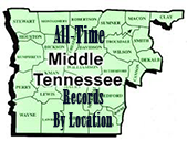
 NWS Weather Forecast  -   Outlook Overnight & Friday
Overnight

Overnight: Showers And Thunderstorms Likely
Showers And T-Storms Likely

Lo 65°F
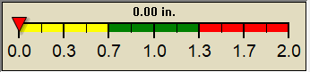
NWS forecast: Showers and thunderstorms likely. Cloudy, with a low around 65. South southeast wind around 5 mph. Chance of precipitation is 60%. New rainfall amounts less than a tenth of an inch possible.
Local station forecast: Mostly clear and cooler.
Friday

Friday: Showers And Thunderstorms then Showers And Thunderstorms Likely
Showers And T-Storms then Showers And T-Storms Likely

Hi 80°F
NWS forecast: Showers and thunderstorms before 10am, then showers and thunderstorms likely. Mostly cloudy, with a high near 80. South southeast wind 5 to 10 mph. Chance of precipitation is 80%. New rainfall amounts between a quarter and half of an inch possible.
 NWS Short Term Weather Forecast
Friday
Night
Friday Night: Showers And Thunderstorms Likely
Showers And T-Storms Likely
Saturday

Saturday: Showers And Thunderstorms Likely
Showers And T-Storms Likely
Saturday
Night
Saturday Night: Chance Showers And Thunderstorms
Chance Showers And T-Storms
Sunday

Sunday: Chance Showers And Thunderstorms
Chance Showers And T-Storms
Sunday
Night
Sunday Night: Showers And Thunderstorms Likely then Chance Showers And Thunderstorms
Showers And T-Storms Likely then Chance Showers And T-Storms
Monday

Monday: Showers And Thunderstorms Likely
Showers And T-Storms Likely
Monday
Night
Monday Night: Showers And Thunderstorms Likely then Chance Showers And Thunderstorms
Showers And T-Storms Likely then Chance Showers And T-Storms
Lo 64°F Hi 80°F Lo 63°F Hi 84°F Lo 64°F Hi 81°F Lo 65°F
ajax-dashboard6.php - Version 6.95h - 20-Feb-2023 - Script by: Scott of BurnsvilleWeatherLIVE.com
Now supported by Saratoga-weather.org Download